Quick Answer
Cappadocia is a region in central Turkey defined by volcanic tuff formations and carved-out valleys, most notably around Göreme, Ürgüp, and Ihlara. The landscape is the result of eruptions from three volcanoes—Erciyes, Hasan, and Melendiz—over thirty million years, creating distinctive fairy chimneys and soft rock ideal for carving. The region holds over 360 Byzantine churches and monasteries carved directly into the stone from the seventh to thirteenth centuries, making it one of Anatolia’s richest archaeological and artistic concentrations.
The Region
In classical times, Cappadocia stretched from the Black Sea to the Taurus Mountains, from the Euphrates to the Salt Lake. After the Persian invasion in the sixth century BCE, the territory was divided: Pontus to the north, Rocky Cappadocia to the south. Today, the most visited part of the region sits in the centre of Turkey, with Nevşehir as its major city.
I have guided visitors through Cappadocia for years, and the thing I tell each group first is that this landscape does not photograph well. The scale — valleys dropping away on every side, hundreds of carved openings in a single rock face — only registers when you are standing in it.
History
The name Cappadocia is Persian: it means a land of fine horses. Horse breeding in the region goes back to the Hittites (1900–1200 BCE) during the Bronze Age. Paying tribute to Persia with horses became an established tradition. Cappadocia was a kingdom in the sixth century BCE. When its people failed against Persian attacks, they became a tributary state of the empire. During Roman times, Cappadocia was an independent state with its capital at Nyssa (today’s Nevşehir). It remained in the Eastern Roman Empire after the division in 395 CE. The Seljuks conquered the area in 1072. Tamerlane invaded in 1405. The region finally became Ottoman territory.
Landscape
The formation of Cappadocia’s landscape began thirty million years ago. Erciyes, Hasan, and Melendiz — three active volcanoes — played the central role. Over millions of years, their eruptions covered the land, 150 kilometres in diameter, with thick layers of volcanic tuff and compressed ash. Water and wind have been shaping the result ever since.
The tuff erodes unevenly. Harder basalt caps protect softer rock beneath, producing the characteristic fairy chimneys — free-standing pillars capped with dark stone. Where the caps have fallen, the pillars erode into cones and ridges. The colours shift with the light: cream, pink, grey, ochre.
The Valleys of Göreme
The Göreme region is of considerable historical and archaeological importance — famous for its rock-cut caves, monasteries, and churches. The landscape owes its existence to Mount Erciyes, an extinct volcano whose lava formations dominate the area. Wind and rain have worn the tuff into free-standing outcrops and towers. Between Nevşehir, Ürgüp, and Avanos, rock-cut dwellings, churches, and monasteries have drawn the attention of travellers and scholars since the nineteenth century.
Rock-cut monasteries were first founded in the region by Basilius, Archbishop of Caesarea, in the fourth century. Soon after, Göreme became a centre of pilgrimage for Christians seeking physical and devotional refuge. The region was named Korama in a sixth-century account of the life of Saint Hieron, who is said to have lived in a rock shelter that was extremely difficult to reach. According to the English historian Skene, Saint George was also of Cappadocian origin — the legends connecting Mount Erciyes with a dragon perhaps account for the frequency of dragons depicted in the rock-cut churches of Göreme.
Göreme was an important centre of Christianity from the seventh to the thirteenth centuries. According to a tenth-century monk who lived in the area, there were about 360 churches and monasteries of various sizes. Most of the churches discovered to date contain frescoes from the ninth to the thirteenth centuries — a period when the monasteries enjoyed prosperity and relative quiet, following years of sectarian disputes, iconoclasm, and Arab invasions.
Cappadocia cannot be considered an artistic centre as important as Byzantium. But the monastic school created here had its own vitality. These are frescoes painted by monks in the churches where they themselves prayed. The visual results are not the product of a formal school — rather, the style of the capital blended with folk art to produce images where sophistication and naïveté sit side by side.
Uçhisar
Three kilometres from Göreme, on one of the roads from Nevşehir to Avanos. Situated on a crest overlooking the entire Göreme region, Uçhisar commands an unmatched view of the tuff formations and surrounding cliffs. The original village was carved into the rocks and concealed from view, but erosion has exposed the rock-cut houses at the foot of a deeply eroded rock face. A postern — a secret passageway — leads from the old houses to the riverbed a hundred metres below, originally used by inhabitants to draw water in secret.
The rock face has eroded until it resembles a ruined castle. Brightly tinted slopes are punctuated with dovecots carved from the rock, their droppings collected annually for agricultural use. Below, the valley winds away into the distance.
Ortahisar
About a kilometre off the Nevşehir–Kayseri road, set on a steep-faced, fortress-like outcrop. The original settlement was substantial — large enough to encompass Kızılçukur, Çavuşin, Elnazar, and Uçhisar at once. The village now clusters at the foot of the fortress, box-like houses packed up the slope with narrow alleys between.
A postern links the fortress to the Christ Citadel, which stands a few hundred metres away on the valley floor. Since no signs of habitation were visible from outside, local Christians used this as a sanctuary during the Arab invasions. Two notable churches survive in the village: the Harim and the Sarıca.
At the village entrance, man-made caves dug from the tuff serve as cold stores for locally produced potatoes, apples, and citrus shipped from the Mediterranean coast.
Çavuşin
Two and a half kilometres from Göreme. The old village was built on slopes below a rock face riddled by erosion, which eventually forced inhabitants to resettle on the plain below. The ruins of the Saint John the Baptist Church — the oldest church in Göreme, dating to the eighth century — stand on the slopes below the rock face. The church has been restored.
Above the road to Avanos, the Çavuşin Church dates to the end of the tenth century. The red-painted frescoes now visible on the facade were originally in the narthex — erosion opened the narthex wall to reveal a triple-apsed, rectangular, barrel-vaulted nave. The tunnel vault suggests the church predates the cross-vaulted churches of Göreme.
The paintings of New Testament scenes are portrayed in detail: the Annunciation, the Visitation, Trial by Water, Joseph’s Dream, the Flight into Egypt, the Three Magi, the Shepherds, the Murder of Zacharias, the Pursuit of Elizabeth, the Massacre of the Innocents, the Healing of the Blind, the Raising of Lazarus, the Entrance into Jerusalem, the Last Supper, the Betrayal, the Crucifixion, the Descent from the Cross, the Burial of Christ, Women at the Tomb, Christ on Mount Olivet, the Ascension, the Transfiguration, and the Angel appearing to Joshua.
Ürgüp
A typical Cappadocian town set on a slope and spreading onto the plain below. The flat-roofed houses, built from volcanic tuff, are warm in winter and cool in summer. The natural stone can be seen along the roads into the surrounding interior — particularly the pinkish variety quarried on the Ürgüp–Avanos road and the rows of fairy chimneys in the stretch between Nevşehir and Ürgüp. The town has hotels, guesthouses, a small ethnographic museum, and a locally grown wine of notable character.
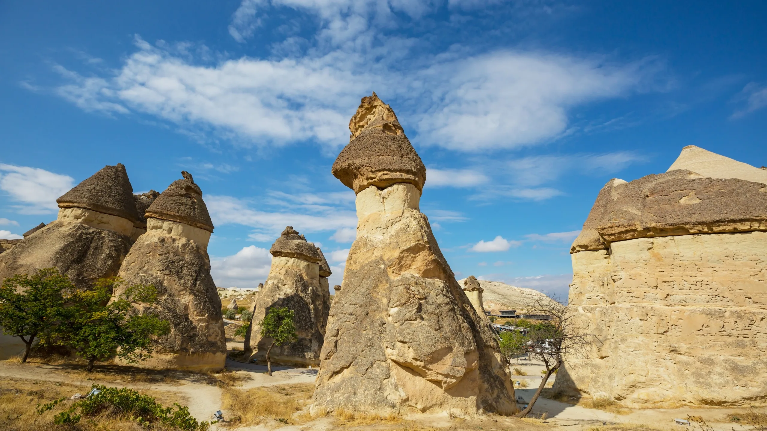
Paşabağ and Zelve
A few kilometres from Zelve, the area of Paşabağ has some of the most complex rock formations in the region — tower-like outcrops in pairs and clusters, or merged into shapes that resist simple description.
The ruins of old Zelve lie at the end of a track 2.5 kilometres off the Çavuşin–Avanos road. This was an important complex of monasteries and churches founded on steep slopes, partly hollowed out of the rock. Like Çavuşin, erosion forced the village to resettle on the valley floor — actually two canyons merging into a gorge. A small minaret shaped like a bell tower still marks the old village.
A small church from the iconoclastic period can be seen at the gorge entrance. The Üzümlü Church interior features medallion rosettes and early Christian symbols: the cross, fish, palm, and vine. The vine is a symbol of Christ in early Christian iconography — “I am the vine and you are my shoots” (John 15:5). Vines appear throughout the wall paintings of Göreme.
Above the old minaret stands a second church, now in ruins. The Geyikli Church contains frescoes of a stag flanking a cross and surmounting a fish. The stag, in the iconography, represents the thirsty soul drinking the water of life. At least five other churches at Zelve remain unopened to the public.
Soğanlı Valley
First described by G. Jerphanion in 1936, this valley is surrounded by high hills and fed by streams. It is both a place of natural beauty and of considerable archaeological interest. Notable churches and monasteries include the Geyikli, Karabaş, Yılanlı, Kübbeli, Yeni, Tahtalı, Ak, and Küçük — each with distinctive features.
Ihlara Valley
The valley of Ihlara was formed by thousands of years of floodwater from Hasandağı volcano and the Melendiz range, cutting deep narrow gorges into the slopes before reaching the Salt Lake. Between the village of Ihlara and the village of Selime, many monasteries and churches were carved from the tuff outcrops — over a hundred, in the Syrian Mesopotamian tradition, lining the rock face of this sixteen-kilometre valley.
A steep stairway leads down the canyon wall into the valley of the churches. Many date from the tenth to the thirteenth centuries, and most are in ruins. Those easiest to access include the Ürenli Seki, Karanlık, Kokar, Ağaçlı, Yılanlı, and Sümbüllü churches — local popular names, as elsewhere in the region.
Near the village of Belisırma, a simply planned church dedicated to Saint George contains frescoes dated to the end of the thirteenth century. The figure of Saint George appears between a man and a woman dressed in Seljuk costume. The names of the Seljuk sultan Gıyaseddin Mesut II (1283–1298) and the Byzantine emperor Andronikos II (1282–1328) are inscribed side by side — evidence of the tolerance of the Turkish rulers toward Christianity.
That inscription — two names from two empires, written together on a church wall in a remote valley — says more about medieval Anatolia than most textbooks manage in a chapter.
Frequently Asked Questions
What is the best time to visit Cappadocia? April to May and September to November offer ideal conditions — mild temperatures and clear skies for photography. Summer (June–August) is hot but visible; winter (December–February) is cold and some valleys are less accessible. Spring is when wildflowers appear on the slopes, making the landscape even more spectacular.
How many churches are really in Cappadocia? Over 360 Byzantine churches and monasteries have been documented across the region. Most date between the seventh and thirteenth centuries. Not all are visible or accessible — many are located high on cliff faces or have collapsed, but enough remain open to visitors that you can see the variety of monastic art and carving styles across centuries.
Why did people carve churches and homes into the rock? The tuff is soft and easy to work with stone tools. Rock-cut dwellings provided natural insulation (warm in winter, cool in summer), protection from invaders, and concealment during periods of religious persecution. The fashion began with Byzantine monks seeking refuge but became a practical building tradition that spread across the region.
Is it possible to visit all the major valleys in one day? One day allows you to see Göreme and one or two additional valleys. For a complete experience of Cappadocia’s variety — Göreme, Ihlara, Soğanlı, and Paşabağ — allow three days minimum. Each valley has its own archaeological character and the landscapes are distinct enough to warrant separate visits.
What should I bring when visiting the rock-cut churches? Comfortable, sturdy walking shoes with grip (the interiors are often uneven stone with no lighting). A torch or headlamp helps you see the frescoes inside darker churches. The openings in the rock provide ventilation, so layers are helpful — it can be surprisingly cool even in summer when you’re inside the stone.
Are the frescoes in the churches original? Many date to the ninth through thirteenth centuries, though some have been heavily restored or are poorly preserved. The finest examples are in churches like the Karanlık (Dark Church) in Ihlara Valley and the Apple Church in Göreme, where pigments and iconographic details remain vivid. Others are fragmentary but still show the skill of the monastic painters.